About the project
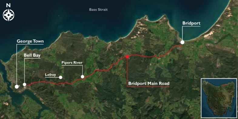
We are developing designs to upgrade Bridport Road between Bridport and Bell Bay to improve freight efficiency and safety.
The upgrades will include shoulder widening, road repairs, slope improvement, and turning lanes at junctions to improve road user safety.
Timing
The program will be rolled out in stages, and we expect designs for the first package of upgrades to several junctions between Weymouth Road and Industry Road to be completed later this year, with construction expected to start in 2026.
We will be carrying environmental investigations along Bridport Road on Friday, 14 November 2025, we don’t expect any impact to road users during this work.
Location
Image: Bridport Road as viewed from above.
View the map below to see the investigations area.

1. Upgrade locations
Our investigations on Bridport Road between East Tamar Highway and Weymouth Road will help further develop designs for upgrades along Bridport Road.
These priority upgrades will include:
- East Tamar Highway to Dalrymple Road – road widening and improvements to the uneven road surface along sections of the highway, between East Tamar Highway and Dalrymple Road
- Bridport Road / Industry Road junction – road widening and installation of a left turn lane for Industry Road
- Industry Road to Pipers River Road – improvements to the road camber (road slope) along with road widening between Industry Road and Pipers River Road
- Bridport Road / Industry Road junction – road widening and installation of left and right turn lanes for Industry Road and the Pipers River General Store
- Bridport Road / Weymouth Road junction – installation of a left turn lane for Weymouth Road.
There will be further opportunities for the public to provide feedback and ideas once the individual project designs have been developed.
We are also investigating further efficiency opportunities by joining efforts and funds with the Freight Capacity Upgrade Program team, to widen the road shoulders on an additional section of the road that was identified requiring repairs. This potential future site is located between Jarvis Link and Little Forester River near Bridport for a length of approximately 4.5km.
View the map below to see the upgrade locations

Bridport Road passes through nearby localities of Lefroy, Pipers River and Pipers Brook, and is situated on the traditional lands of the Northern clans, the Leenerrerter and Pyemmairrenerpairrener people.

2. Community consultation
Community consultation has now been completed for this project.
View the Feedback Summary Report (PDF 414.7 KB).
For more details, please email bridportroadsafety@stategrowth.tas.gov.au.
If you have accessibility requirements to allow you to participate fully, please call the project team on 03 6210 0662 or email bridportroadsafety@stategrowth.tas.gov.au.
3. FAQs
How far has the project progressed?
We are developing designs to upgrade Bridport Road between Bridport and Bell Bay, to improve freight efficiency and safety.
The upgrades will include shoulder widening, road repairs, slope improvement and turning lanes at junctions to improve road user safety.
Will the project require land acquisition?
Some partial land acquisition may be required. As the design progresses, we will identify the need for any land acquisition and discuss with the respective landowners.
4. Funding
The Australian Government has committed $16 million towards the project with an additional $4 million in funding committed by the Tasmanian Government.
A further $4M was also recently committed by the Australian Government, and another $4M by the Tasmanian Government, bringing the total funding commitment for this project up to $25M.
Accessibility
If you would like to find out more information and you have accessibility requirements, please contact the project team (details below).
You can find out more about Transport Services' commitment to accessibility.
Contact
For more information about this project, please email bridportroadsafety@stategrowth.tas.gov.au or call the project team on 03 6210 0662.
