1. What does the app do?
The app tells drivers when travel times will be longer than normal for that time of the day, for example when crashes or roadworks cause delays.
The app also gives regular updates about how long it will take to get from one location to another at specific locations on key routes, such as the Southern Outlet or the East Tamar Highway.
The app also provides a map displaying delays to travel times to assist with trip planning.
2. What doesn’t the app do?
The app is designed for people that are familiar with the road network and the usual traffic conditions.
The app won’t give drivers alerts about normal, or recurring congestion that happens every day, for example during morning or afternoon peak travel times.
Alerts and Travel Time information will not be available in areas not covered by Bluetooth detectors.
3. What equipment do I need?
To use the app, all you need is a Bluetooth enabled IOS or Android smart device.
You don’t need a Bluetooth enabled car stereo system for the app to work, but if you do have one and your phone is connected to your car stereo, then you can listen to app alerts through the car stereo.
4. Do I need an internet connection for the app to work?
The app doesn’t require an internet connection for spoken alerts, but it does need a connection to update background information, to display the map, delay lines and incident icons, and download new messages.
5. Do I need to turn Bluetooth on for the app to work?
Bluetooth must be enabled to receive spoken alerts.
6. Do I need to turn Location Services on for the app to work?
Yes, to allow the app to function accurately, Location Services will need to be turned on, even when the app is not in use. Please select “allow all the time” when prompted when installing the app, or turn location services on from your phone settings.
7. Do I need the screen active to hear alerts?
No, you only need the app to be running in the background to hear alerts.
8. Is it safe to use the app while driving?
It is never safe to handle your phone while driving.
This is why the TrafficTAS app is designed to work in the background, without you having to touch your phone.
You can look at your route on the app’s map view before you start your journey. You can also use Navigation Mode if you have your device safely mounted in a hands-free device in your car while you are driving.
Otherwise, you can just leave the app running in the background on your device with Bluetooth switched on and it will send audio alerts when there are delays detected on your route.
9. I want to choose what alerts I hear
You can decide which alerts you hear in the settings menu of the app under “Alert Categories”.
You will find three alert types: incident alerts, route travel time alerts and information alerts.
To hear about delays then leave the “incident alerts” on, as this provides information on incidents (crash/roadworks or other event) with predicted travel delays.
The “route travel time” provides frequent updates on travel time and any delays on your regular travel route.
The third category, “information alerts” provides additional information about delays on the network (e.g. road closure due to a snow event). We suggest keeping these on too.
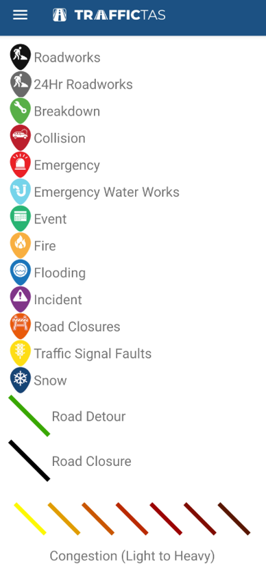
10. Map legend
The legend describes the types of map icons that can be used and the meanings of the line colours displayed on the map. In the Android app, you can find a copy of the Map Legend in the menu. In the Apple app, the key is located in the bottom right hand corner of the map.
